
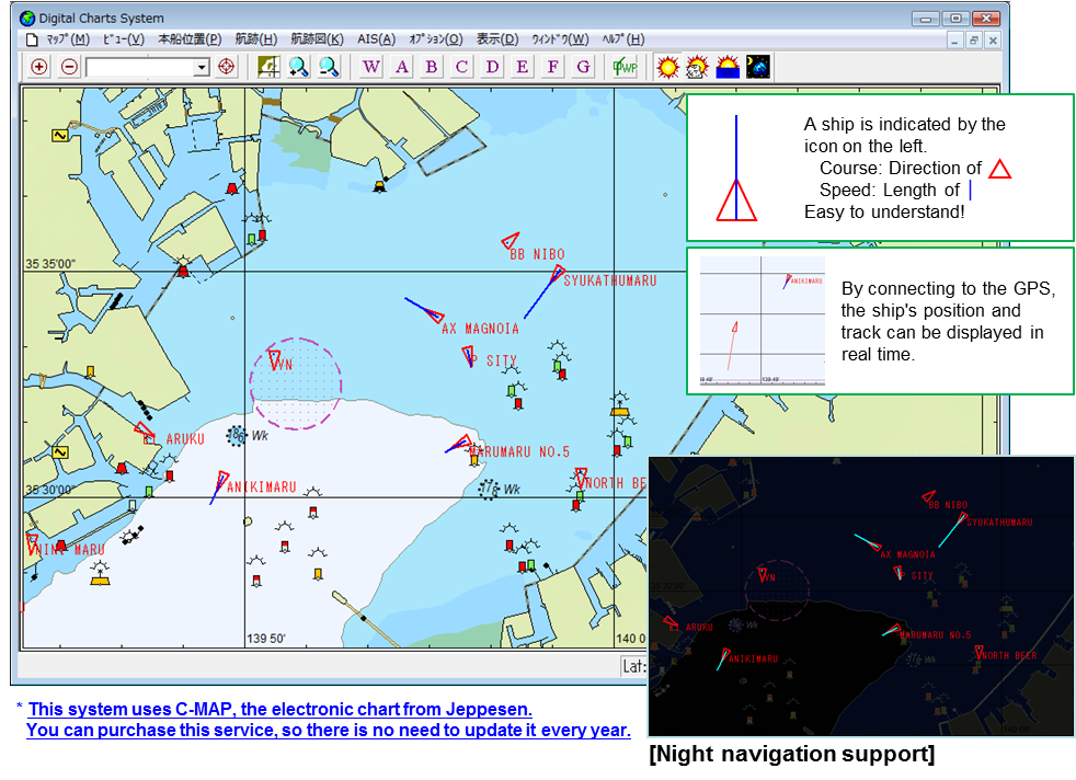
SeaViewer allows users to easily view AIS and GPS information on their PCs. It graphically displays information about their own ships and other ships (position, direction, course, and speed) on an electronic chart.
This system allows users to display their past ship tracks and make route plans. It also supports a night navigation screen and provides an optional feature for displaying vector diagrams of tides.
This system allows users to display their past ship tracks and make route plans. It also supports a night navigation screen and provides an optional feature for displaying vector diagrams of tides.
Sample screen
[Past tracks display]
You can see your past tracks!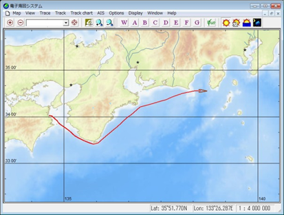
[AIS information]
A list of other ships and various types of information can be easily displayed.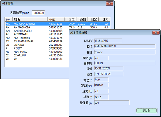
[Major Functions]
1. Basic functions
1) Displaying AIS information
AIS information can be graphically displayed on the electronic chart.
2) Displaying GPS information (ship's position and track)
The ship's position and a 24-hour track history can be displayed in real time. (GPS connection is required.)
3) Creating and displaying a route plan
A route plan can be easily created by using a mouse and entering values. The created route plan can be displayed together with the ship's position and track.
4) Calculating the distance between two points and displaying an area of 200 nautical miles
The distance between two points can be calculated and an area of 200 nautical miles can be plotted by using a mouse.
5) Displaying past tracks (a time period can be specified)
The ship's past navigation tracks can be displayed on the chart. The period can be specified for past tracks, and by operating the mouse on these tracks, the position information can be output as a CSV file.
2. Optional functions
1) Displaying winds and tides visually
Information on winds, currents, and tides can be visually displayed as vector lines on the ship's track. (Connection with an anemometer and tidal current meter is required.)
2) Notifying track information by email
By using external communication tools such as data communication terminals (mobile phones), maritime telephones, etc., the ship's position can be sent at regular intervals to the specified email address.
3) Checking the ship's position and track from the office
By installing this system on a land computer, the ship's position and track can be checked from the office. (Separate communication is required.)
[Configuration Example 1] Configuration for a single PC
![[Configuration Example 1] Configuration for a single PC](https://www.exa-corp.co.jp/user/images/SeaViewer_E_4.png)
[Configuration Example 2] Configuration for a data gathering computer
![[Configuration Example 2] Configuration for a data gathering computer](https://www.exa-corp.co.jp/images/SeaViewer_E_5.png)
Please contact the E-mail address below.
お問い合わせ
CONTACT
Webからのお問い合わせ
エクサの最新情報と
セミナー案内を
お届けします